Property Record
1073 S Enota Dr Ne, Gainesville, GA 30501
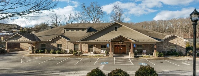
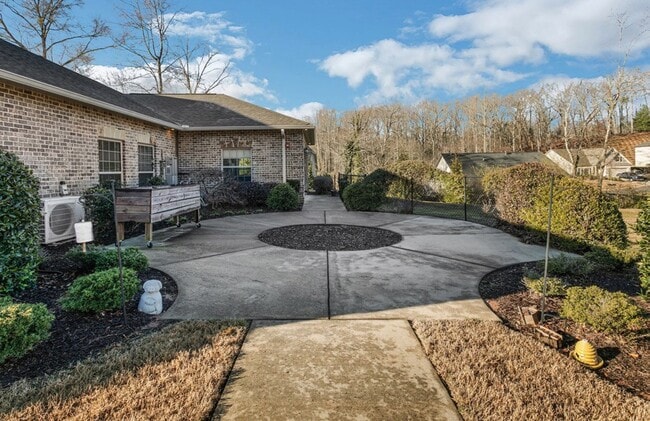
This Property Is For Sale
NEARBY LISTINGS FOR SALE OR LEASE
-
-
View all Gainesville listings for sale on LoopNet.com
Property Detail
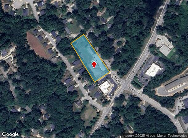
1073 S Enota Dr Ne
Gainesville, GA
F O Parks Subdivision
01-00077-01-081
LOTS 3 - 7 OF THE F O PARKS SUBDIVISION
Retirementnursinghomecombined
Hall
X
Georgia
13139C0179G
3-7
2025
2 AC
2025
Gainesville/Hall County
000901
Atlanta
9,633 SF
DEMOGRAPHICS near 1073 S Enota Dr Ne
1 Mile
3 Mile
5 Mile
2024 Total Population
7,014
37,697
72,806
2029 Population
7,655
41,454
79,845
Pop Growth 2024-2029
+ 9.14%
+ 9.97%
+ 9.67%
Average Age
40
37
37
2024 Total Households
2,921
13,658
25,320
HH Growth 2024-2029
+ 9.11%
+ 9.83%
+ 9.62%
Median Household Inc
$54,622
$53,123
$57,341
Avg Household Size
2.30
2.60
2.70
2024 Avg HH Vehicles
2.00
2.00
2.00
Median Home Value
$290,730
$277,091
$272,248
Median Year Built
1978
1984
1988
Nearby Places
- Restaurants
- Banks
- Shops
- Fitness
- Groceries
PUBLIC TRANSPORTATION
COMMUTER RAIL
DRIVE
WALK
Distance
5 min
2.7 mi
Nearby Properties
Address
Land Use
TOTAL SIZE
Lot Size
Zoning
Address
Land Use
TOTAL SIZE
Lot Size
Zoning
564,132 SF
48.45 AC
PUD
Address
Land Use
TOTAL SIZE
Lot Size
Zoning
66,720 SF
27.49 AC
PUD
Address
Land Use
TOTAL SIZE
Lot Size
Zoning
34,131 SF
80.82 AC
L-I
Address
Land Use
TOTAL SIZE
Lot Size
Zoning
39,637 SF
31.55 AC
R-II
Address
Land Use
TOTAL SIZE
Lot Size
Zoning
27,221 SF
2.23 AC
G-B
Address
Land Use
TOTAL SIZE
Lot Size
Zoning
2,160 SF
5.60 AC
PUD
Address
Land Use
TOTAL SIZE
Lot Size
Zoning
44,052 SF
19.19 AC
PUD
Address
Land Use
TOTAL SIZE
Lot Size
Zoning
58,020 SF
3.15 AC
PUD
Address
Land Use
TOTAL SIZE
Lot Size
Zoning
237,470 SF
155.08 AC
L-I
Address
Land Use
TOTAL SIZE
Lot Size
Zoning
3,620 SF
20.20 AC
PUD
Address
Land Use
TOTAL SIZE
Lot Size
Zoning
100,864 SF
4.10 AC
PUD
Address
Land Use
TOTAL SIZE
Lot Size
Zoning
2,038 SF
20.92 AC
R-II
Address
Land Use
TOTAL SIZE
Lot Size
Zoning
77,333 SF
11.74 AC
PUD
Address
Land Use
TOTAL SIZE
Lot Size
Zoning
19,875 SF
19.76 AC
R-B
Address
Land Use
TOTAL SIZE
Lot Size
Zoning
56,780 SF
16.78 AC
PUD
Address
Land Use
TOTAL SIZE
Lot Size
Zoning
76,726 SF
0.42 AC
C-B
Address
Land Use
TOTAL SIZE
Lot Size
Zoning
46,795 SF
17.38 AC
PUD
Address
Land Use
TOTAL SIZE
Lot Size
Zoning
102,317 SF
6.90 AC
PUD
Address
Land Use
TOTAL SIZE
Lot Size
Zoning
11,430 SF
38 AC
R-I
Address
Land Use
TOTAL SIZE
Lot Size
Zoning
128,531 SF
13.32 AC
R-I
Address
Land Use
TOTAL SIZE
Lot Size
Zoning
148,619 SF
30.75 AC
O-I
Address
Land Use
TOTAL SIZE
Lot Size
Zoning
54,720 SF
32.52 AC
R-II
Address
Land Use
TOTAL SIZE
Lot Size
Zoning
1,441 SF
10.46 AC
PUD
Address
Land Use
TOTAL SIZE
Lot Size
Zoning
25,386 SF
30.22 AC
AR-1
Address
Land Use
TOTAL SIZE
Lot Size
Zoning
140,805 SF
3.74 AC
PUD
Address
Land Use
TOTAL SIZE
Lot Size
Zoning
4,032 SF
89.43 AC
R-I
Address
Land Use
TOTAL SIZE
Lot Size
Zoning
467,600 SF
38.17 AC
L-I
Address
Land Use
TOTAL SIZE
Lot Size
Zoning
63,571 SF
31.97 AC
PUD
Address
Land Use
TOTAL SIZE
Lot Size
Zoning
82,610 SF
13.68 AC
G-B
Address
Land Use
TOTAL SIZE
Lot Size
Zoning
123,944 SF
13.21 AC
G-B
The World's #1 Commercial Real Estate Marketplace
Connect with us
© 2025 CoStar Group
The information above has been obtained from sources believed reliable. While we do not doubt its accuracy we have not verified it and make no guarantee, warranty or representation about it. It is your responsibility to independently confirm its accuracy and completeness. Any projections, opinions, assumptions, or estimates used are for example only and do not represent the current or future performance of the property. The value of this transaction to you depends on tax and other factors which should be evaluated by your tax, financial, and legal advisors. You and your advisors should conduct a careful, independent investigation of the property to determine to your satisfaction the suitability of the property for your needs.